BATHYMETRIC SURVEYS
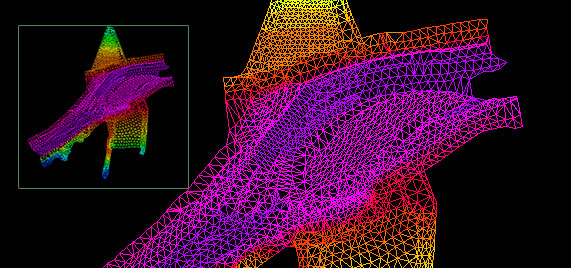
Bathymetric surveys are conducted to study and better understand what lies beneath the surface of a water body. These types of surveys can be carried out on lakes, rivers, streams and oceans to determine depth of the feature, volumes, and can also be used to generate a detailed 3D digital terrain model or wireframe model of the bed or floor of the water body.
These surveys are carried out using an echosounder integrated into a GNSS RTK system related a control network. The equipment used can be mounted on to a small remotely operated boat or a manned vessel. The echosounder outputs a multibeam signal in a fan-like shape (swath). Once the data is collected, it can be viewed and processed to deliver a high-quality product.
- Preliminary pipeline routing
- Contours and detailed elevation maps
- Volumes
- Flood prediction and mitigation
- Depth of cover
- Spill mitigation
- Dam installation and removal
- Construction of bridges
Contact us at Precision Geomatics for all your surveying needs, today!
OUR COMMITMENT
Plans & Mapping
Comprehensive Plans and Mapping that address all stakeholders concerns and meets licensing requirements.
Productivity
Using innovation and qualified staff to increase productivity to meet timelines and avoid delays.
Minimize Costs
Minimize costs through risk mitigation along with experience to focus on critical tasks.
Experience
Synergizing the variety of expertise within Precision to support the best overall product.
Accuracy
Critical in Land Surveying and in producing third party documents for licensing and agreements.
